Map
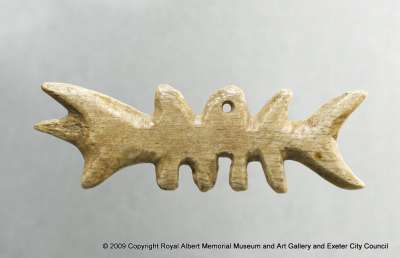
This is a 3-dimensional, tactile coastal map made from Caribou antler. It acted as an aid for the Inuit hunter at night by providing essential information on landmarks and distance. This one would have been attached to clothing or worn around the neck.
Normally such maps were made from driftwood. These small maps were intended to be carried within one’s mittens. Such maps represented coastlines in a continuous line, up one side of the wood piece and then down the other. They’re designed to be buoyant, tactile and could be read during the dark hours.
Originally listed in accession register as “carved bone, Dibble’s Hill, Santa Barbara, California.” Acquired by WSM D’Urban.
L. 120 x W. 38mm
Possibly inherited by D’Urban from his paternal grandfather Sir Benjamin D’Urban, who was appointed Commander-in-Chief of the British forces in Canada, 1846. William Stewart Mitchell D’Urban accompanied him at the age of 10 until 1849 when he became infected with diptheria. An attempt to cure him left him deaf, and prevented him from following his father and grandfather into military service. D’Urban instead became a keen naturalist.
Object Summary
- Accession Loan No.
- 633/1902
- Category
- Ethnography
- Collection Class
- Scientific instruments
- Collection Area Region
- N
- Material
- caribou antler
- Common Name
- map
- Simple Name
- map
- Inscription Transcription
- Dibble’s Hill, Santa Barbara, CALIFORNIA
- Production County
- eastern
- Production Country
- Canada
- Production Year High
- 1902